Autonomous UAS and AI mission systems for complex operating environments.
maxUAS develops autonomous UAS and AI mission systems for complex civil, industrial, public-sector, and defence/security environments. At the center of our portfolio is Sentinel-AI, a standalone operational intelligence platform that helps teams make sense of sensor, imagery, telemetry, and field data in real time.
Sentinel-AI is a platform-agnostic intelligence layer that ingests data from third-party sensors, existing operational systems, overhead imagery, and simulated mission sources, with maxUAS quadcopter, fixed-wing, and VTOL aircraft available for field data collection and mission support.
Our systems are designed around Canadian-controlled engineering, auditable supply chains, and non-adversarial component strategies. Platform and software architectures are being developed for cold-weather, Arctic, GNSS-challenged, and infrastructure-limited environments where operational reliability and traceable decision-making matter.
From sensor observations to operator-ready decisions.
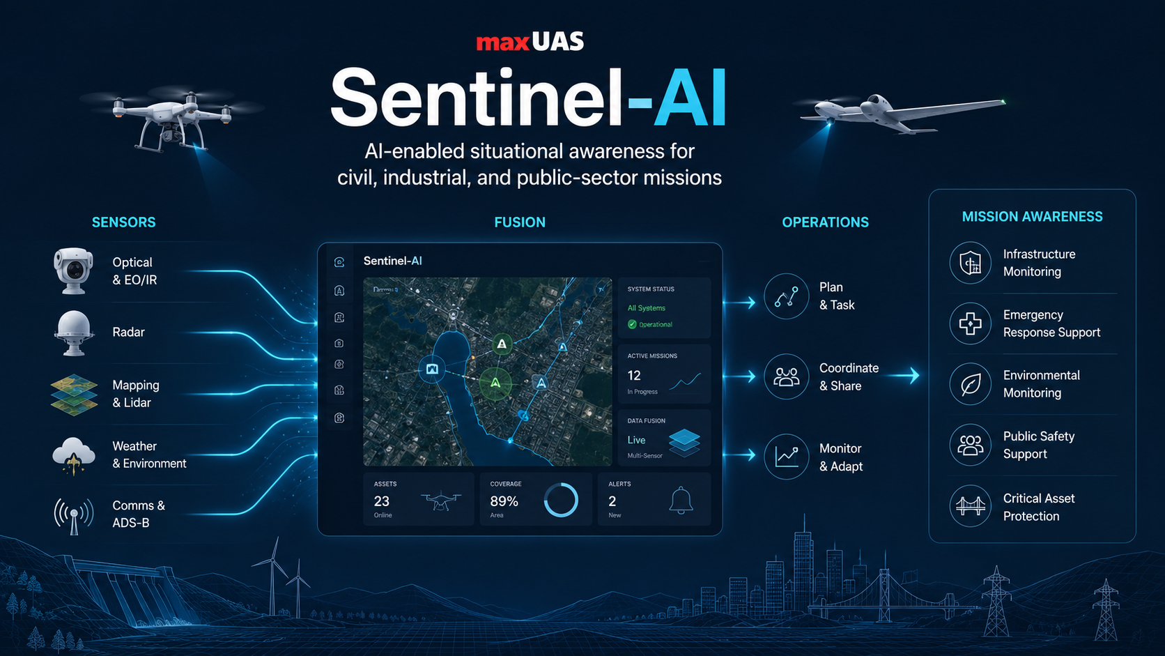
Sentinel-AI is a mission intelligence platform that connects maxUAS aircraft, payloads, external sensors, telemetry, operator inputs, customer data, and mission context into one decision workflow. It helps operators move from raw observations to a clearer operational picture while preserving evidence, confidence, provenance, and human oversight.
Rather than treating each drone, camera, radar feed, range measurement, RF cue, acoustic cue, customer data source, inspection record, operational report, or historical mission dataset as a separate island, Sentinel-AI brings them together into a common structure for track management, sensor correlation, mission alerts, operator confirmation, audit logs, reporting, and operational intelligence. By connecting existing customer data with live field observations, Sentinel-AI helps organizations identify patterns, highlight changes, support faster review, and produce confidence-supported insights that are easier for operators and decision-makers to act on.
The gap: detection alone is not enough
Many systems detect and alert, then leave operators to investigate, maintain contact, and coordinate next steps manually. In Arctic, maritime, remote, public-safety, and forward-site environments, operator-intensive models can become difficult to sustain when infrastructure, connectivity, weather, or response time is constrained.
The solution: Sentinel-AI closes the loop
Sentinel-AI is positioned as an integrated awareness, coordination, and response system. It supports informed decision-making, deploys or cues response assets when configured, maintains visibility, and records key decisions within customer-defined rules, oversight levels, and compliance requirements.
Multi-modal sensor fusion
Ingest and correlate radar, EO/IR, RF, acoustic, telemetry, UAS, and external sensor observations into a common operating picture.
Operator-in-the-loop control
Support policy-based automation where cueing, investigation, tracking, and response coordination remain aligned with authorization levels and safety controls.
Interoperability-ready architecture
Designed for integration pathways with sensor adapters, mission planning tools, command systems, telemetry streams, and standard data formats.
Operator decision support
Sentinel-AI is designed to help operators prioritize what matters: where the object is, what evidence supports it, how confident the system is, what changed, and what next action is available under customer policy.
Mission-configurable autonomous systems, not just airframes.
maxUAS platform families are designed to work alongside Sentinel-AI through payload kits, autonomy options, onboard compute, operator workflows, and mission data integration.
Civil, industrial, public-sector, and defense/security missions
Built to serve demanding civil and industrial work such as inspection, mapping, environmental monitoring, and emergency response, while remaining configurable for government, security, ISR, perimeter surveillance, and time-sensitive missions subject to policy, compliance, and customer requirements.
Payloads, autonomy, sensors, radios, and workflow integration
Modular payload bays, configurable autonomy stacks, onboard compute, and integration pathways for sensors, radios, mission planning, telemetry, and data workflows allow one platform family to support multiple programs without reinventing the operational workflow.
maxUAS quadcopter platforms
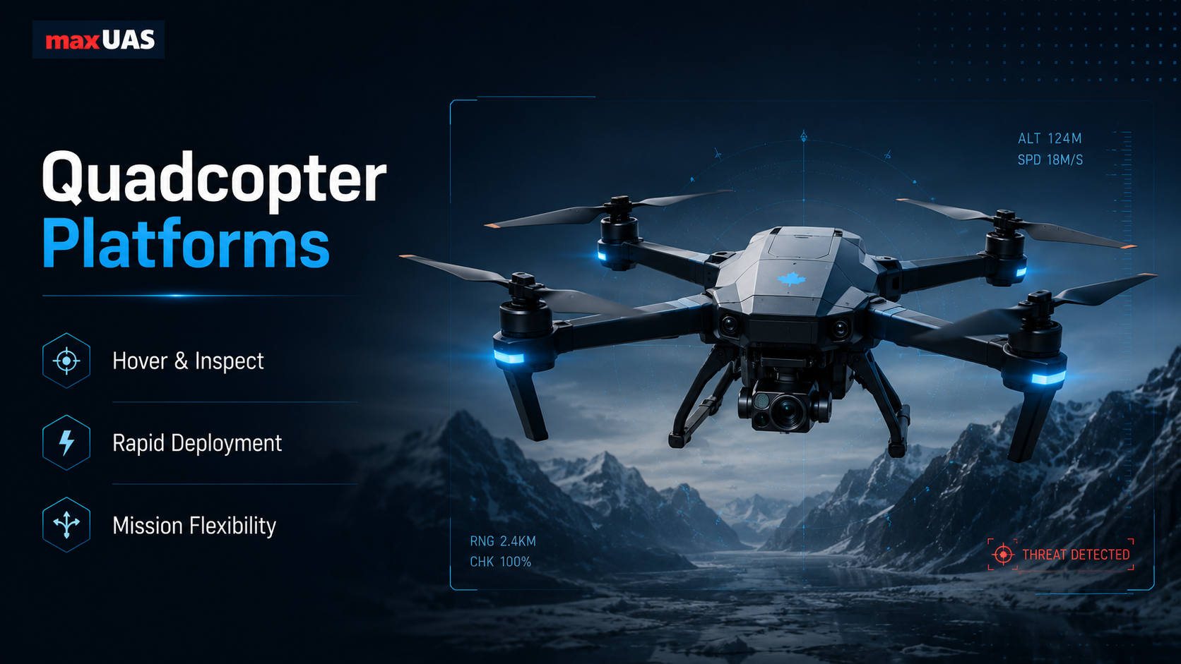
maxUAS can provide mission-configured quadcopter UAS platforms for operations that need precision positioning, short setup time, close-range inspection, controlled overwatch, and launch from constrained sites. These vertical-takeoff systems can be configured with payload, autonomy, communications, and Sentinel-AI workflow options matched to the customer’s operating environment.
For civil and industrial users, maxUAS quadcopter configurations can support asset inspection, emergency response, confined-area mapping, public-safety overwatch, and remote site checks. For regulated security and defense-adjacent users, the same platform category can be configured for perimeter observation, localized ISR, sensor cue investigation, relay support, and operator-confirmed mission tasks.
- Configurable stable hover, low-speed maneuvering, and station-keeping for precise observation.
- Rapid launch and recovery from roadsides, yards, rooftops, remote clearings, and improvised operating areas.
- Mission-kit options for EO/IR, laser range-finding, mapping, edge compute, relay, RF/acoustic, or custom payloads.
- Suitable for close inspection, local surveillance, scene assessment, perimeter checks, and response support.
- Available with Sentinel-AI workflows for cueing, evidence capture, operator confirmation, and mission logging.
maxUAS long-range fixed-wing platforms
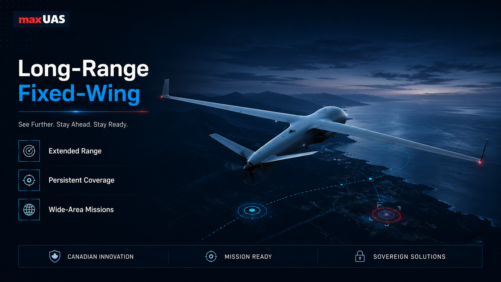
maxUAS can provide long-range fixed-wing UAS configurations for missions where endurance, efficient cruise, and wide-area coverage matter more than hover capability. These platforms can be configured to cover corridors, coastlines, remote terrain, large properties, and patrol routes with lower energy-per-kilometre than a multirotor profile.
This makes maxUAS fixed-wing configurations suitable for pipeline and powerline patrol, maritime and coastal awareness, search-area coverage, environmental monitoring, wildfire/flood reconnaissance, border/perimeter support, and ISR-style observation where the customer needs coverage over distance and time.
- Configured efficient cruise for longer-range missions and persistent coverage.
- Corridor patrol options for roads, rail, pipelines, transmission lines, coastlines, and remote routes.
- Wide-area mapping and monitoring with repeatable flight plans and structured data capture.
- Mission payload options for imaging, mapping, environmental sensing, relay, and onboard processing.
- Integration with Sentinel-AI for telemetry, mission observations, sensor measurements, and operator-confirmed events.
maxUAS VTOL-capable configurations
maxUAS can provide VTOL-capable UAS configurations for missions that need vertical deployment flexibility combined with fixed-wing endurance. These hybrid concepts are suited to remote, Arctic, maritime, and expeditionary operations where runway access or fixed infrastructure may not be available.
- Vertical launch and recovery options for infrastructure-limited sites.
- Fixed-wing cruise configurations for longer coverage tasks.
- Mission-kit flexibility for inspection, ISR, mapping, relay, and overwatch.
- Optional Sentinel-AI integration for cueing, operator workflow, mission records, and response coordination.
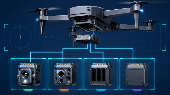
Payload options
Payloads are treated as mission kits that adapt the same airframe families to different customer tasks. A configuration can be built around imaging, EO/IR, mapping, compact laser range finding, edge AI compute, RF/acoustic sensing, environmental sensors, communications relay, or a customer-defined payload.
The goal is to keep payload integration consistent across mechanical mounting, power, data, payload identification, operator controls, and mission records. That allows maxUAS to configure a system for inspection, ISR, airspace awareness, mapping, measurement, relay, or specialized sensing without making the payload the entire identity of the aircraft.
Mission kits that extend the same platform family across different use cases.
Payloads are presented as configurable options within the maxUAS architecture. Rather than spreading one sensor concept across the whole system, each payload is treated as a mission kit that can be combined with the appropriate airframe, autonomy level, onboard compute, communications package, GCS workflow, and Sentinel-AI integration.

Laser range-finder payload
A compact laser range-finder payload can support precision ISR, range measurement, target cueing, and operator-confirmed observation records. When paired with stabilized imaging, platform pose metadata, timestamps, and Sentinel-AI evidence handling, range measurements become part of a traceable mission data product rather than a standalone sensor reading.
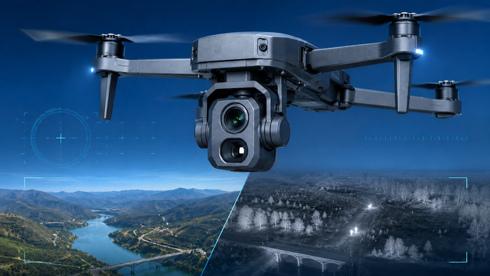
EO/IR and stabilized camera payloads
Day/night imaging payloads can support inspection, search, overwatch, reconnaissance, perimeter monitoring, maritime awareness, and emergency response. Stabilization and repeatable flight planning help operators collect consistent imagery across multiple sorties.
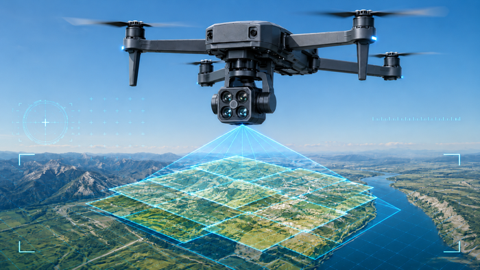
Mapping and photogrammetry
High-resolution mapping cameras for orthomosaic generation, survey workflows, construction documentation, terrain analysis, and repeatable site monitoring.

LiDAR / terrain sensing
Optional terrain and structure sensing for vegetation penetration, elevation models, infrastructure inspection, and operations where image-only mapping is not sufficient.
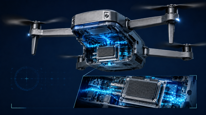
Edge AI compute
Onboard compute modules for local detection assistance, sensor pre-processing, video analytics, payload control, data quality checks, and degraded-link operation.
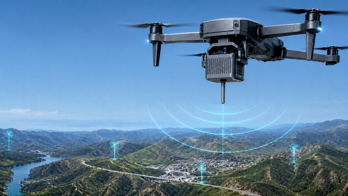
RF detection payload
RF sensing options for signal awareness, emitter detection support, spectrum monitoring, and correlation with other Sentinel-AI observations.
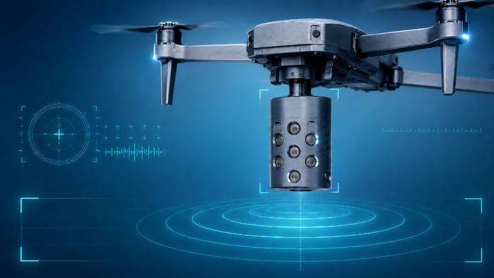
Acoustic sensing
Acoustic payloads or ground-linked acoustic feeds can contribute additional detection evidence in airspace awareness, security, and environmental monitoring scenarios.
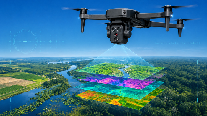
Multispectral / environmental
Mission kits for forestry, agriculture, coastline, wetlands, habitat, snow/ice, and environmental monitoring where specialized bands or sampling data are useful.
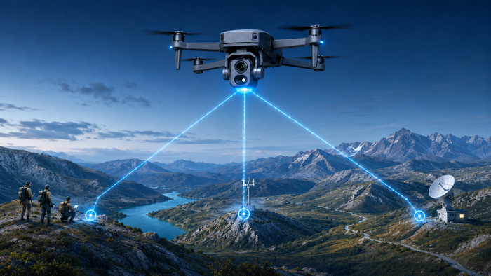
Communications relay
Airborne relay payloads can extend network reach, support field teams, improve coverage in terrain-limited areas, and maintain mission continuity when infrastructure is limited.
Custom customer payloads
Customer-defined sensors can be integrated through modular power, data, mounting, payload identification, and operator workflow interfaces when mission requirements demand a specialized configuration.
Payload kit architecture
Mission-kit interface architecture for imaging, EO/IR, mapping, telemetry, compute, custom sensors, and customer-defined payload requirements.
Payload data stack
Payload outputs such as EO/IR imagery, mapping data, range measurements, RF/acoustic observations, platform pose metadata, mission timestamps, and operator confirmation can be combined into structured mission data products.
Core building blocks for complex missions.
The emphasis is on practical mission execution: Sentinel-AI mission intelligence, reliable autonomy, configurable payload integration, operator-aligned workflows, traceable outputs, modular payload options, and resilience in real operating environments.
Sentinel-AI mission intelligence
Standalone operational intelligence platform for connecting sensor, imagery, telemetry, customer, and field data into clearer situational awareness, confidence-supported insights, evidence handling, and operator-ready decision workflows.
Autonomy and mission execution
Support for autonomy levels that match the operator’s SOP, ranging from flight assistance to higher automation. Defined routes, geofences, predictable behaviours, and repeatable mission plans help teams collect comparable data across sorties.
GPS-challenged operations
Configurations intended to support operations where GNSS is degraded, intermittent, or unreliable. Depending on the mission kit, this can include navigation aids, SLAM/VIO/IMU fusion, and autonomy features that improve continuity and reduce risk.
Modular payload architecture
Payload integration designed around mission kits: imaging, mapping sensors, EO/IR packages, laser range finding, edge compute, RF/acoustic sensors, relay modules, telemetry, and custom payloads can be integrated through standardized interfaces.
Comms and integration pathways
Integration points for mission planning, telemetry, sensor feeds, command workflows, analytics, and customer-specific toolchains, reducing friction when UAS outputs need to fit into existing operations.
Interoperability pathways
Designed with integration pathways for standards and formats such as SAPIENT-style sensor integration, ASTERIX radar track ingestion, Cursor-on-Target style messaging, ATAK-compatible operational workflows, and customer-specific command systems.
Cold-weather operational resilience
Environmental design considerations, cold-weather power planning, maintainability, variable-terrain deployment, logistics constraints, and infrastructure-limited workflows for harsh Canadian and Arctic operating realities.
Rapid deployment and fieldability
Focus on setup time, serviceability, maintainability, logistics, and mission packages that can be swapped or reconfigured without requiring extensive engineering effort in the field.
Safe, repeatable data capture
Optimized for inspection, mapping, environmental monitoring, asset observation, and emergency response workflows where operational reliability and decision-quality data are more valuable than raw speed or novelty.
Configurable for regulated environments
Configurable for ISR, border/perimeter surveillance, force protection support, airspace awareness, and integration into broader security systems, subject to policy, compliance, and customer requirements.
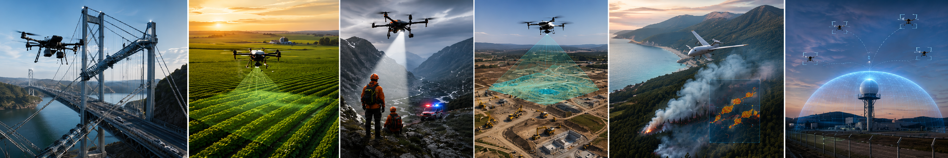
Balanced mission coverage across civil, public-sector and regulated security environments.
All use cases are presented here as mission applications that can combine Sentinel-AI, maxUAS aircraft, payloads, external sensors, customer data, and operator workflows. Each application can be mapped to a platform choice, refined through payload and autonomy options, and connected to Sentinel-AI when the customer needs sensor fusion, operator cueing, evidence handling, reporting, or decision support.
Infrastructure inspection
Repeatable inspection of utilities, bridges, industrial sites, rail, transportation assets, and critical infrastructure. The goal is consistent imagery and telemetry so teams can monitor change over time, reduce manual risk, and minimize downtime.
Mapping and surveying
Photogrammetry, survey support, land-use planning, project documentation, volume estimation, and large-area mapping with repeatable mission execution rather than ad-hoc flight collection.
Environmental monitoring
Forestry, coastal, wetlands, habitat, and remote-area monitoring with scheduled re-flights that produce comparable datasets across seasons, incidents, or program timelines.
Emergency response support
Situational awareness, scene mapping, and search support for disaster response and SAR teams, improving visibility and reducing time-to-information in dynamic environments.
ISR and reconnaissance
Day/night ISR support through mission-configured payloads, autonomy options, repeatable routes, time-on-station, and consistent observation workflows.
Border and perimeter surveillance
Monitoring of sensitive areas, patrol routes, perimeter overwatch, coastal sites, and rapid response to cues from external sensors or operators.
Force protection support
Situational awareness for bases, forward sites, routes, public-sector facilities, and critical infrastructure where deployment speed and reliable visibility are essential.
Maritime domain awareness
Coastal and near-shore monitoring workflows where endurance and coverage are critical for littoral patrol, vessel observation, and wide-area awareness.
Precision measurement and target cueing
When configured with a laser range-finder payload, small UAS can support accurate range measurement, georeferenced observation, target cueing support, operator confirmation, and auditable mission records.
Airspace and perimeter awareness
Airspace and perimeter awareness is one use case enabled by Sentinel-AI, maxUAS aircraft, payloads, external sensors, customer data, and operator workflows. Sentinel-AI can connect radar, EO/IR, RF, acoustic, telemetry, aircraft feeds, external cueing sources, and operator inputs into one coordinated operational picture to help teams detect, review, track, coordinate, and record activity according to their policies, regulations, and mission requirements.
When configured for regulated security or counter-UAS support, this application can assist with detection-to-response coordination, operator cueing, evidence trails, audit logs, role-based response workflows, airborne investigation or overwatch support, and integration into broader security or C-UAS system-of-systems environments.
Arctic and High North support
Support for remote and cold-weather operating areas where distance, weather, infrastructure limits, and communications constraints make reliable awareness, fieldability, and traceable mission data important.
Forward and temporary site awareness
Deployable awareness for forward sites, temporary operating locations, public-sector facilities, and remote work areas where small teams need rapid setup, coordinated visibility, and recorded decision workflows.
Public events and sensitive locations
Support for public safety, government sites, transportation hubs, and sensitive locations where operators need situational awareness, controlled workflows, appropriate human oversight, and accountable records.
From requirements to operational configuration.
maxUAS is a Canadian autonomous systems and AI technology company developing Sentinel-AI, a standalone mission intelligence platform, along with autonomous UAS platforms and modular payload architectures for demanding civil, industrial, public-sector, and defence/security environments. Sentinel-AI is designed as a standalone operational intelligence platform that can connect customer data, sensors, imagery, telemetry, aircraft feeds, and mission context into clearer situational awareness.
Define the mission
Clarify operating environment, coverage area, payload needs, autonomy level, data workflow, and compliance constraints.
Configure the system
Select platform category, payload kit, compute, comms, Sentinel-AI modules, and GCS/operator workflow requirements.
Validate and deploy
Move through pilot, demonstration, integration, training, and operational deployment steps appropriate to the customer environment.
Request a tailored capability brief.
Tell us your mission profile and constraints: target application, coverage area, endurance/range needs, sensor or payload type, comms constraints, operating environment, autonomy requirements, and whether you are validating a pilot or planning an operational deployment.